GIS传道者 · 精选文章
共 1672 篇精选

ArcGIS Hub at the 2026 Esri User Conference
The 2026 Esri User Conference is almost here, and the ArcGIS Hub team couldn’t be more ready to connect with you. This year we’re bringing a full lineup of ArcGIS Hub–focused techn
小程序阅读全文

8.05亿,卫星公司并购卫星公司
封面、内文图片由AI生成 撰文 | 泰伯网 苏言 本文非AI生成 泰伯网讯,8月26日晚间,A股上市公司高凌信息发布30多个公告,其中相关公告表示,公司拟通过发行股份及支付现金的方式购买凯睿星通信息科技(南京)股份有限公司(简称“凯睿星通”)89.49%的股份,交易金额约8.05亿元,同时募集配套资金。 图源:东方财富 从行业领域来看,高凌信息与凯睿星通
小程序阅读全文
Anthropic拟向投资者披露超30万亿美元市场潜力,IPO估值目标约2万亿美元
Anthropic正就IPO筹备向投资者描绘一幅前所未有的市场愿景。 8月25日,据《华尔街日报》援引知情人士透露,这家Claude聊天机器人制造商拟告知投资者,其潜在市场总规模(TAM)将超过30万亿美元,超越SpaceX此前创下的28.5万亿美元纪录。 Anthropic预计2028年收入将达约1900亿至2000亿美元,IPO估值目标约为2万亿美元,高
小程序阅读全文

Introducing the Void Analyzer infographic: Void analysis made simple
Exciting news: In July 2026, we are introducing two new Void Analyzer infographics in Business Analyst Web App. These infographics allow our users to quickly identify which busines
小程序阅读全文
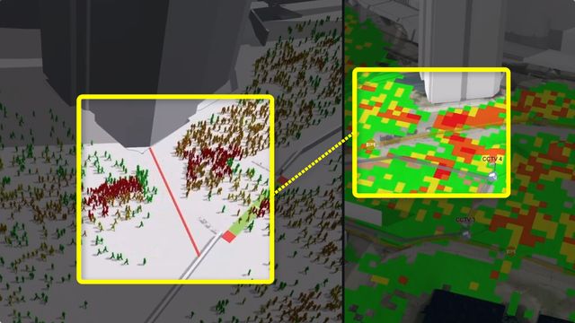
From 2D Plans to 3D Intelligence: How a Digital Twin Can Transform Safety at a Special Event
A conceptual walk-through of how ArcGIS and crowd simulation turn event planning data into a predictive public safety tool before the first fan ever arrives. The Challenge of Manag
小程序阅读全文

Building an Automated Flood Monitoring Workflow with Sentinel-1 RTC Imagery
Floods are among the world’s most destructive natural hazards, making timely and reliable flood mapping essential for emergency response, damage assessment, and recovery planning.
小程序阅读全文
泰伯早报 | 8月29日:国家航天局:搭建跨境遥感数据合作平台等;1.49亿,莱斯信息、中国铁塔等联合中标低空项目;“全球空间智能第一股”上半年AI收入增177%
【商业航天】 ① 8月25日,2026文昌国际航空航天论坛在海南省文昌市开幕。国家航天局总工程师李国平在论坛上表示,面向“十五五”发展新征程,国家航天局将统筹高质量发展和高水平安全,加快构建科学规范、安全有序、高质量、可持续发展的航天产业体系和发展格局。李国平表示,国家航天局坚持开放合作,积极促进航天成果共享。深化卫星数据与应用的国际合作,搭建安全有序、高效
小程序阅读全文
XY coordinates only from BP BATAM
Question i've got x y coordinates only, no CRS, no projection What can I do? https://postimg.cc/3Wf4m8M1 Question — andi · GIS Stack Exchange · 2026-05-12 Answer Georeferenced with
小程序阅读全文
PyQt5 classes cannot be imported in a QGIS build based on Qt6. Error installing plugin
Question PyQt5 classes cannot be imported in a QGIS build based on Qt6. Use PyQt6.QtCore or preferably the version independent qgis.PyQt.QtCore import instead (where available).
小程序阅读全文
QGIS - Opposite of vector (join attributes by location) - remove duplicate features
Question I have two QGIS shapefile layers (and databases). Database A seemingly contains duplicate shapefiles from Database B (and shapefiles). Within B, slight edits have been don
小程序阅读全文
QGIS: Raster to Vector conversion crashing my computer
Question I am trying to convert a 7,000,000 kb raster file into a vector file within QGIS. To do this, I planned to use "Raster pixels to polygons" within the processing toolbar. I
小程序阅读全文
泰伯早报 | 8月30日:我国首次实现地月双向高速激光通信;两部委重磅发文:扩大低空物流装备应用等;空客拟出售美国航天业务
【商业航天】 ① 从中国科学院空间应用工程与技术中心获悉,日前,我国在地月激光通信试验任务中取得重要突破,成功在超过40万公里的地月距离上建立起双向激光链路,首次实现地月双向高速激光通信。这标志着我国空间激光通信正式从近地轨道迈入地月空间。(央视新闻) ② 美国总统特朗普当地时间周五签署行政命令,宣布成立美国太空学院,计划将其打造为一所兼具军事和民用属性的全
小程序阅读全文