GIS传道者 · 精选文章
共 1672 篇精选

Developer's Lounge: Creating a Documentation Site to Help Developers Navigate ArcGIS Hub
Andrew Turner is a Chief Technology Officer (CTO) at Esri, leading the team that builds and maintains ArcGIS Hub. The mission of ArcGIS Hub is simple: connect people with the infor
小程序阅读全文
Planet’s Tanager-2 Moves Hyperspectral Earth Observation Toward Operational Cadence
Planet has shipped Tanager-2 and 18 SuperDove satellites to Vandenberg Space Force Base for SpaceX’s Transporter-18 mission. The SuperDoves provide the numerical headline, but Tana
小程序阅读全文
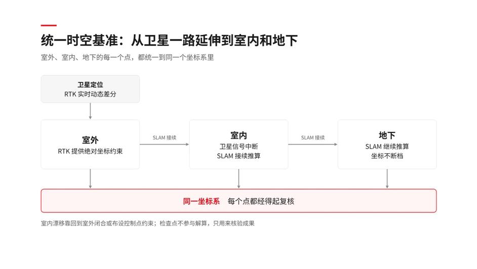
从“扫得到”到“查得清”:手持三维扫描交付的三道关
过去几年,手持三维激光扫描在国内外快速普及。设备越来越轻,一个人走一遍,就能拿到一层楼、一段隧道的点云。但在测绘和工程现场,越来越多的项目卡在了采集之后:坐标在室内外切换处断档,长走廊里点云出现分层,成果交出去,甲方问一句“精度怎么证明”,一时答不上来。 2026年10月15日,在重庆召开的2026中国地理信息产业大会上,自然资源部总规划师张兵提出实施“时空
小程序阅读全文
Overture’s August Release Shows Open Maps Becoming Data Infrastructure
Overture Maps Foundation’s latest release is easy to describe as another increase in address points, transport features and physical geography. The more consequential story, howeve
小程序阅读全文

跑赢“最后一公里”,普适导航如何解构商业航天的下半场?
文**|**泰伯TIC 图|AI生成 2026年,中国商业航天迈入“黄金时代”。 中国航天迎来可回收技术发展新阶段、商业火箭发射频率刷新纪录、低轨卫星星座加速组网、民营航天企业集体冲刺IPO……在新一轮发展周期中,卫星“上天”正在变得越来越容易。 但与此同时,一个更加现实的问题逐渐浮现:卫星上天之后,谁来把数据变成价值?商业航天的下半场,不仅需要“上天”,更
小程序阅读全文
GeoAI Maps the Surface of 9.2 Million Kilometres of Roads
Most global road maps can tell us where a road is. Far fewer can tell us whether it is paved, how wide it is, or whether it might keep a relief convoy moving after a flood. A new p
小程序阅读全文
QGIS正式禁止提交AI生成的代码了...
10 月 7 日,QGIS 官方仓库正式合并了一份编号为 QEP428 提案,不允许任何 LLM、AI 或智能体辅助生成的代码。其实 QGIS 做这件事情已经不是第一次了,小编大约翻了一下讨论和邮件列表,今天就和大家聊聊这件事。 查看原文配图 规定详情 正式条文有两条。 一是禁止任何 LLM、AI 或智能体辅助的代码贡献进入QGIS仓库;二是事后若发现违规,
小程序阅读全文
Pixxel Raises $100M to Build the Full Earth Hyperspectral Intelligence Stack
Pixxel has raised $100 million to evolve from a hyperspectral satellite operator into a vertically integrated Earth intelligence company. The Series C was co-led by Temasek and Ser
小程序阅读全文
泰伯早报 | 10月28日:四大运营商:成立卫星公司;上海“星枢计划”2032年计划完成千星部署;知名具身智能公司陷欠薪停工风波
【商业航天】 ① 10月25日,我国在海南商业航天发射场使用长征八号甲运载火箭,成功将卫星互联网低轨28组卫星发射升空。博主定焦数码暗示,华为很早便在手机中内置了低轨卫星互联模块,这意味着华为将成为业内第一家支持低轨卫星通信的手机品牌。(快科技) ② 10月27日,2026卫星互联网产业生态大会在上海召开,复旦大学党委副书记、副校长迟楠在会上公布了“星枢计划
小程序阅读全文
Why Stage Five Is Buying Indoor Location Specialist Loplat
South Korean mobile operator Stage Five is acquiring indoor location intelligence company Loplat through a comprehensive share exchange. Under the September 2 announcement, Loplat
小程序阅读全文
NATO Is Shopping for Geospatial Data That Can Survive the Real World
NATO is testing the market for something more demanding than another global map. A new request for information from the NATO Communications and Information Agency, or NCIA, asks in
小程序阅读全文

武汉一时空AI智能体公司融资数千万,投资人为百川智能联合创始人
封面、内文图片由AI生成 撰文 | 泰伯网 苏言 本文非AI生成 泰伯网讯,近日,武汉中地数字孪生技术有限公司(以下简称“中地数字孪生”)宣布完成由西藏恒翊极智人工智能合伙企业(有限合伙)领投的千万级天使轮战略融资。 据悉,本轮投资方西藏恒翊极智人工智能合伙企业(有限合伙)成立于2026年4月,公司事务执行人茹立云,担任清华大学天工智能计算研究院副院长,曾任
小程序阅读全文